State
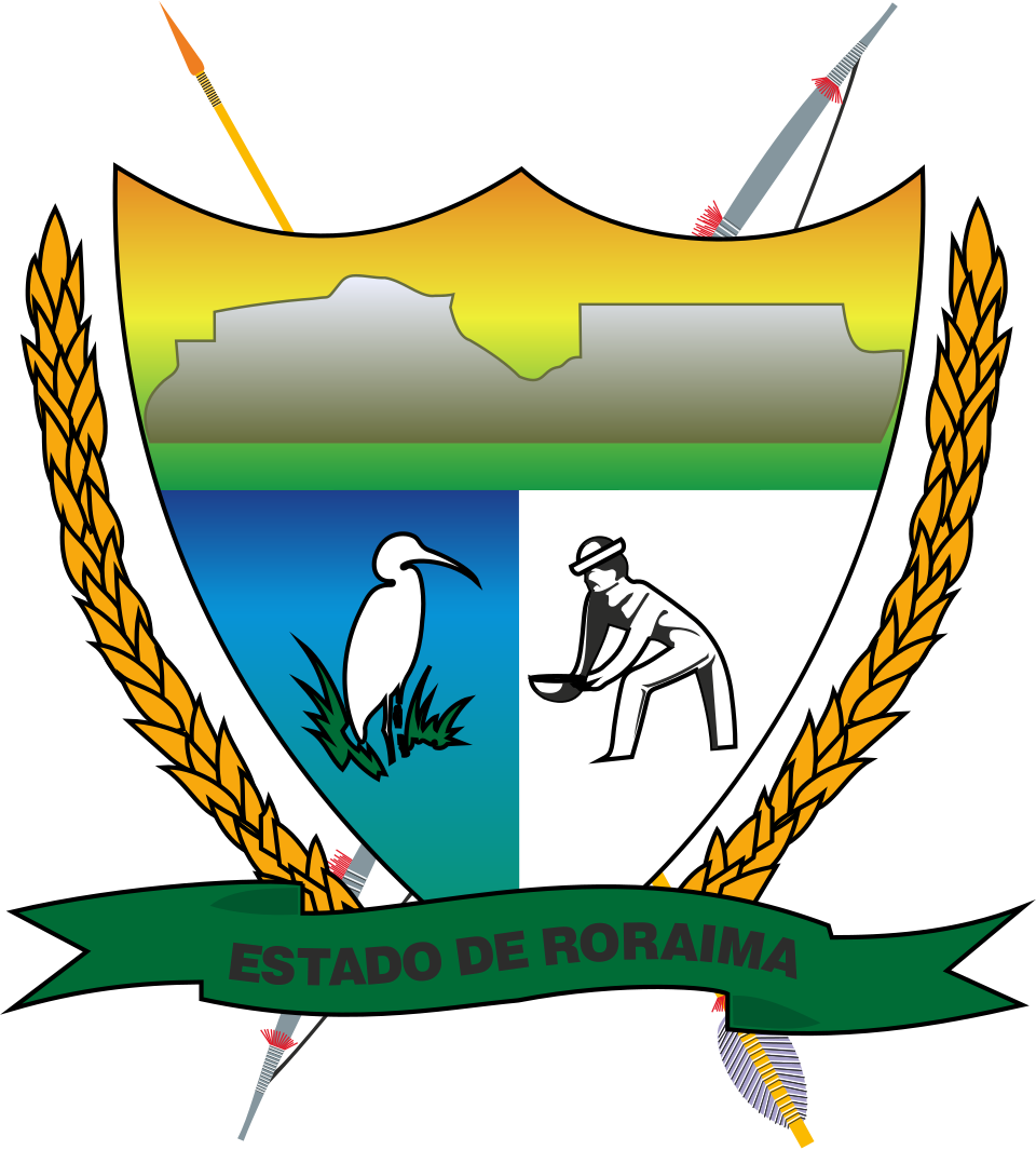
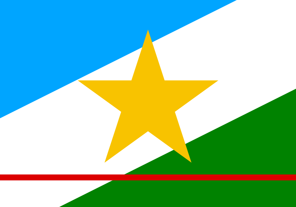
At the northernmost tip of Brazil, entirely above the Equator, lies Roraima — a state that takes its name from the towering Mount Roraima, a tepui shared with Venezuela and Guyana that inspired Sir Arthur Conan Doyle's The Lost World. Created as the Federal Territory of Rio Branco in 1943, renamed Roraima in 1962, and raised to statehood by the 1988 Constitution, it is home to Brazil's highest concentration of Indigenous peoples — including the Macuxi, Wapichana and Yanomami — and to the lavrado, a savanna landscape unlike anything else in the Amazon. The coat of arms, adopted while Roraima was still a territory, centres on Mount Roraima beneath a seven-coloured rainbow; the flag, adopted after statehood in 1996, crosses diagonal bands of blue, white and green with a narrow red stripe for the Equator.
Flag
Not available
Coat of Arms
Not available
| State | Roraima (Federal Territory of Rio Branco from 1943, renamed Roraima in 1962, state since 5 October 1988) |
|---|---|
| Capital | Boa Vista — the only Brazilian state capital located entirely north of the Equator |
| Region | North (Norte) |
| Borders | Amazonas and Pará (Brazil); Venezuela and Guyana |
| Population | ≈ 636,700 (2022 census) — Brazil's least populous state |
| Coat of arms adopted | 1982, Decree 56, while still the Federal Territory of Roraima |
| Flag adopted | 14 June 1996, by State Law 133 |
| Designers | Antônio Barbosa Melo (coat of arms); Mário Barreto (flag) |
| Note | Statehood came 45 years after the territory's creation and 2 years after the coat of arms was already in use |
Coat of Arms — Mount Roraima beneath a seven-coloured rainbow, framed by emblems of the territory's peoples, minerals and wildlife.
The coat of arms of Roraima is built around a light-blue shield in a modern, non-European emblematic style typical of Brazil's twentieth-century state arms. At its centre rises Mount Roraima, the flat-topped tepui that gives the state its name, overarched by a rainbow of seven colours. Below the mountain a white band carries the inscription ESTADO DE RORAIMA. The shield is flanked by stalks of rice, an Indigenous weapon evoking the territory's native peoples, a garimpeiro (gold prospector) recalling the mineral rushes that shaped the region's economy, and a white egret, a bird characteristic of Roraima's wetlands and savanna. The crest above the shield bears a five-pointed gold star, and a narrow red band across the composition alludes to the Equator, which cuts through the state.
Long before it bore this coat of arms, the region was home to the Macuxi, Wapichana, Yanomami, Taurepang and other Indigenous peoples. Portuguese colonisation reached the area in the eighteenth century with the construction of Fort São Joaquim (1775) at the confluence of the Uraricoera and Tacutu rivers, built to secure the empire's northern frontier. In 1943, President Getúlio Vargas carved the Federal Territory of Rio Branco out of Amazonas as part of a wider strategic reorganisation of Brazil's frontier regions; the territory was renamed Roraima in 1962. The coat of arms was adopted in 1982 by Decree 56, chosen through a public competition and designed by Antônio Barbosa Melo — meaning the emblem predates statehood by six years. The 1988 Constitution finally elevated the territory to a full state of the federation, with the change taking effect in 1990. In 2005, the Brazilian Supreme Federal Court upheld the demarcation of the Raposa Serra do Sol Indigenous Territory as a single continuous area, a landmark ruling for Indigenous rights in Brazil.
Flag — Diagonal bands of blue, white and green, crossed by a narrow red band bearing a gold star.
Roraima's current flag was adopted on 14 June 1996 by State Law 133, some eight years after statehood, replacing the plainer banner that had served the Federal Territory until the transition to statehood took full effect around 1990. It was designed by the artist Mário Barreto and is one of the few Brazilian state flags built on diagonal, rather than horizontal or vertical, bands.
The flag consists of a rectangle (proportions of roughly 7:10) crossed by three diagonal bands rising from the lower-left to the upper-right corner: turquoise blue, white and flag green. Near the bottom edge runs a separate, narrower red band, and at the centre — overlapping the red band and extending beyond the width of the white diagonal — sits a gold five-pointed star.
The flag flies over all state government buildings and presides over official ceremonies in Boa Vista. At regional festivities — such as the folk festival of Pacaraima and Indigenous Peoples' Day observances — the state flag is displayed alongside Indigenous symbols, reflecting the cultural coexistence that defines Roraima.
The seven-coloured rainbow at the centre of the shield stands for peace and harmony among the diverse peoples of Roraima, an allusion often linked to the state's many Indigenous ethnic groups, including the Macuxi, Wapichana, Yanomami, Taurepang, Ingaricó, Wai Wai and others.
The area was created as the Federal Territory of Rio Branco in 1943 under President Getúlio Vargas, renamed the Federal Territory of Roraima in 1962, and elevated to full statehood by the 1988 Federal Constitution, with the transition taking effect in 1990.
Three diagonal bands of turquoise blue (the sky and clean air), white (peace) and green (the forests and cerrado), with a narrow red band representing the Equator, and a gold star for mineral wealth and for Wezen, the star that represents Roraima on Brazil's national flag.
The coat of arms was designed by Antônio Barbosa Melo and adopted by Decree 56 of 1982, while the state was still a federal territory. The flag was designed by Mário Barreto and adopted by State Law 133 of 14 June 1996, after statehood.
Mount Roraima is a tepui — a flat-topped table mountain — on the triple border with Venezuela and Guyana, and one of the oldest exposed rock formations on Earth. It gave the state its name and appears on the coat of arms as the emblem of Roraima's singular geography; it also inspired Sir Arthur Conan Doyle's novel The Lost World.
Last reviewed by the Emblema Mundi editorial team on 2026-07-04.